
The weather at the end of January was a hot topic of conversation.
While the data is still unofficial for Jasper, the numbers seem to show that Jasper had a record-breaking day for heat on Jan. 30, according to Alysa Pederson, meteorologist with Environment and Climate Change Canada.
As of Feb. 1, however, the government organization’s website has an ‘M’ for missing information for that data, likely thanks to its automated system flagging it for review.
“I think what might have happened is that the number from Tuesday was so high that it got automatically just cancelled until the climate team can actually have a look at it. That happens sometimes,” she said.
Unofficially, the daytime high was 14.7 C, and there was a lot of snow and ice melting to prove it.
Interestingly, the time of day that it reached that temperature was not in the middle of the afternoon as one might expect but in the middle of the night, a result of wind gusts due to an upper ridge.
“Three a.m. is when it hit 14.7 C,” Pederson said. “It then cooled off immediately when the winds died down, and then the daytime temperature at 3 p.m. went back up to 12.3 C.”
The previous record for that day was 11.7 C set in 1935.
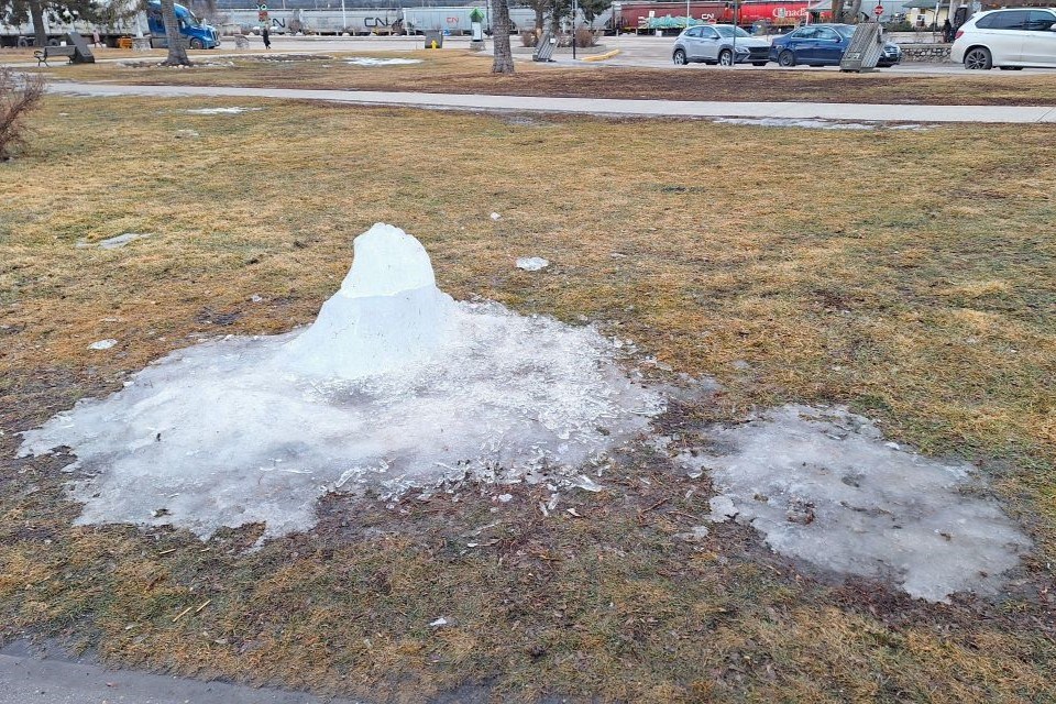
Around town, signs of the heat were everywhere. People walked around wearing shorts. The Jasper in January ice sculpture installed only days before had gone from a shoulder-height art piece to an ankle-height ice bump on the grass. The circular skating lane set up on Mildred Lake looked more like it was about to turn into a swimming lane as the already thin ice turned into thick, sloppy puddles.
The weather also forced ACFA Jasper to postpone the pentathlon until Feb. 10 in the hopes of giving Mildred Lake a chance to get back into sporting shape.
Much of the province and even across the Prairies experienced the same unseasonably warm weather. Pederson said the five-to-seven centimetres of snow that Edmonton had was pretty much gone.
That upper ridge was related to an atmospheric river that brought much precipitation to the southern British Columbia the weekend prior.
“An atmospheric river is a very strong jet stream, essentially, that brings precipitation and moisture and tropical air. In this case, it was from the Hawaii area,” Pederson said on Thursday, Feb. 1.
“But because of that strong flow, we got what we call an amplified upper ridge. All that warmer air pushed up into Alberta, even into southern Northwest Territories. It was quite amplified right across southeastern B.C. That upper ridge pushed up and over Alberta, Saskatchewan and parts of Manitoba and sat here for a couple of days. It’s actually still sitting over us.”
It was a “very significant warm dome,” one that brought the highest January temperatures that ECCC has seen for some places.
The record for Jan. 31 was also broken this year, reaching 8.6 C.
January 29’s record still stands at 13.3 C (again from 1935) contradicting the ECCC’s weather page for Jasper, which indicates that this year’s 13.1 C became the new record. That is because the data that shows online is only threaded for the last 25 years, Pederson said.
“We're extremely above normal being 10 to 12 degrees for the last couple of days,” she said.
Jasper saw more record daytime highs of 11.1 C and 8.8 C on February 1 and 2, even as Balzac Billy predicted six more weeks of winter on Groundhog Day.
A cooling trend going into the weekend brought milder daytime highs of 4.4 C and -0.1 C on Saturday and Sunday, respectively. Southern parts of the province received 10 to 20 or more centimetres of snowfall, which brought only 0.2 mm of precipitation to Jasper. That snow will continue to bring cooler air into parts of central Alberta, dropping temperatures to about or just above normal for this time.
Starting on Thursday this week, overnight lows in Jasper are expected to go back closer to where they belong in mid-February, reaching -10 C and colder.
Looking into mid-February, there are currently no signs that Jasper is going back into a deep freeze. The monthly forecast is indicating above normal as per the recent trend.
“That being said, towards the end of the month, we could have another cold snap,” Pederson said. “That does tend to happen in February.”


