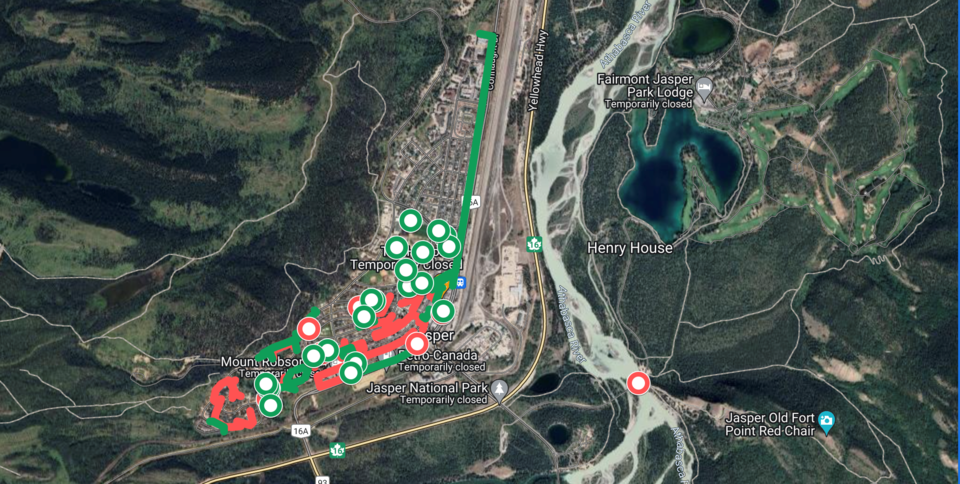
Canadians have been anxiously waiting for updates and images to reveal the extent of the wildfire damage in Jasper. While officials have refrained from sharing too much before proper assessments can be made, videos and photos taken from within the restricted fire zone started leaking out over social media on Wednesday.
The sometimes catastrophic images have caused wide ranging speculation about the severity of the structural damage incurred in the town. A project using Google Maps hopes to compile these images, verify their authenticity, and geolocate them on a map of Jasper to piece together a more complete picture of the aftermath.
Great West Media spoke with the person behind the Jasper Wildfire Damages (JWD) 2024 map, who wants to remain anonymous.
“I have been following the horrible situation in Jasper very closely, including the 'leaked' operations map that many (myself included) interpreted as showing destroyed properties. Ultimately, I realized that the visual record coming out of the town is probably the most reliable evidence we have at the moment and deserves to be properly compiled,” they said.
A photo of a map (different from the JWD 2024 map) of the Jasper townsite circulated online, causing Parks Canada to release a statement Wednesday.
“This map is not an official incident map. It was a hastily drawn operational map used by structural protection to identify areas to focus their response efforts. It does not represent damage to specific properties or the extent of damage to any individual area or property," they said about the leaked operations map on Wednesday.
To avoid spreading bad information, any footage included on the JWD map is verified using Google Maps and Streetview, the map creator said in an email.
“If I am not sure where any piece of imagery was taken, I do not add it to the map. Luckily, a lot of the material comes with location context added, either by the posters themselves or by commenters.”
Still, the project should not be mistaken for an official account of damages but more of a stop-gap measure while we wait for better information to emerge, they said.
“I just want to make it very clear that the markers I'm drawing are to be taken with a huge grain of salt, because mapping the extent of the damages from often low-quality footage is obviously very inaccurate. The primary goal is not to build an exhaustive map of the destruction but to give a spatial context to the footage that we're seeing online. Hopefully, we will soon have information coming through official channels to properly assess the extent of this tragedy.”
Having many fond memories of repeat trips to Jasper, reviewing the footage has brought a mix of heartbreak and relief, they said.
“I remember seeing the video taken along Connaught Drive, coming from the north end of the town down to Miette Ave. One of my favourite spots in Jasper is the Bear's Paw bakery, and I was very happy to see that it was still standing. Plus, I think it was the first video to show that major portions of the town seem to be largely intact, which of course came as a huge relief.
“Overall, I've been heartbroken watching everything unfold over the past two days. My heart goes out to everyone who is affected by this, no matter how big or small their loss. But at the end of the day, the absolutely most important thing of all is that everyone made it out of town alive. Whatever videos or pictures we see, no matter how devastating they are, I think we should always be thankful that the people of Jasper still get to hug their loved ones and kiss their kids goodnight.”


