
JASPER – Residents and business owners of Jasper now have a sense of if their homes and/or businesses were destroyed by the devastating wildfires in the national park.
On Saturday (July 27), the Municipality of Jasper revealed a map and street address sheet of where wildfires have done the most damage within the mountain townsite of Alberta.
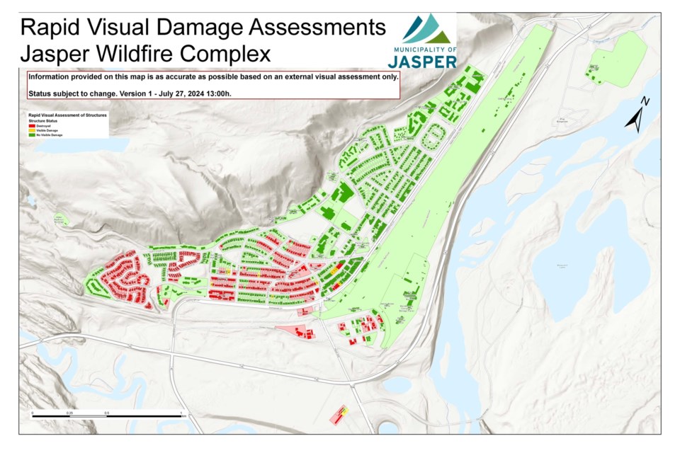
On the coloured map, green indicates no visible damage, yellow is visible damage and red is destroyed.
The municipality said the “information is still preliminary and is based on the damage that is visible from the street.”
“With evacuees located across multiple communities, staying at centres or with friends and family. We are challenged with the ability to communicate during an evacuation, and this is the most efficient way to reach as many Jasperites as possible. Updates will continue to be provided on the Municipality of Jasper’s website and Facebook page,” stated the municipality.
According to the map, most of the destruction occurred in the south and south west of the townsite.
"Buildings marked as 'not damaged' on the map could also have internal damage caused by smoke and water. Consider this a preliminary description of properties affected in Jasper," the municipality stated.
Some of the destroyed buildings named on the map include Pine Grove Senior Citizen’s Manor, Anglican Church Hall, Mount Robson Inn, Maligne Inn, and Sunwapta Apartments.
Esso Gas station and the Petro-Canada Gas Station were both destroyed by fire.
Listed on the map as having no visible signs of damage include the RCMP police station, and the Municipality of Jasper’s bylaw office, municipal office and maintenance compound. The CNR Building, Parks Information Centre, Cottage Medical Clinic, Mountain Park Housing Co-operative, Our Lady of Lourdes Catholic Church, Best Western Inn, Marmot Lodge, Cavell Court Apartments, and Sawridge Inn are also named on the map as having no visible signs of damage.
In an update on the devastating wildfires on Saturday afternoon, Alberta Emergency Management Agency (AEMA) said critical infrastructure within the Jasper townsite has been protected, such as the hospital, emergency services building, schools, activity centre and the wastewater treatment plant, but firefighting efforts within the town and national park remain ongoing.
On Friday (July 26), Stephen Lacroix, AEMA senior assistant deputy minister and managing director said it will be weeks before residents, who fled the incoming wildfire danger at nighttime last Monday, will be able to return to the fire-ravaged town.
Approximately 17,100 people have evacuated Jasper National Park since then.
According to Parks Canada, the wildfire was assessed at approximately 32,000 hectares in size, or 320 square km, making it the largest wildfire in more than 100 years in Jasper National Park.
Approximately 30 per cent of the town's buildings were destroyed by the wildfire.


