
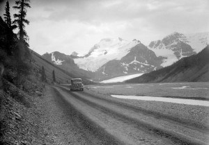
It’s been described as one of the most scenic drives in the world and you’d be hard-pressed to find someone who thinks otherwise.
From sweeping valleys and sprawling glaciers to the dizzying heights of snow-capped mountains, the meandering 230-km road from Jasper to Lake Louise is more than just a drive, it’s a journey.
Few people know this better than First Nations people and European fur traders who regularly traversed the mountain passes and valleys to hunt and trade in the area long before the highway was built.
“The first people that would have travelled in the area where now Highway 93 or the Icefields Parkway goes would have been the First Nations people,” said Kirsten Schmitten, during a presentation about the history of the highway on Feb. 9.
According to historical records, First Nations moved through the area for thousands of years before the first Europeans arrived, using the area to travel, hunt and gather, homestead and for religious purposes.
The Aseniwuche Winewak, or Rocky Mountain People, is one of more than 20 indigenous groups with ties to the area.
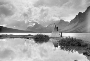
As the first Europeans started to arrive, indigenous groups took on a new role helping to guide scientists, surveyors and fur traders in the area, such as David Thompson.
“The who-is-who list using the pony trails where the Icefields Parkway is now is incredible,” said Schmitten, pointing to legendary explorers such as Mary Schaffer, Molly Adams and David Douglas.
In the spring of 1827, David Douglas, a botanist working on behalf of the Hudson’s Bay Company, crossed the Athabasca Pass, a major trading route through the Rockies, north of the Columbia Icefield. During his expedition he decided to climb a nearby peak that he claimed rivaled the Himalayas.
The elusive peak remained a mystery for subsequent explorers until nearly 60 years later, when, in 1884, professor Arthur Coleman, a geologist with the University of Toronto, visited the Rockies in search of the legendary mountain. Using Douglas’s journals and famed maps, he negotiated the Great Divide from Banff to Jasper House, in search of the mountain.
Although unsuccessful in his quest, he ultimately discovered what would become the route of Highway 93.
But before a roadway was ever discussed, other early explorers and entrepreneurs, such as Jack Brewster, saw an opportunity to exploit the Rockies’ natural beauty and began offering guided trips to tourists along what he called the “glacier trail.”
“He would do an annual trip every year starting in 1917 and he would start either at the Jasper end of the Banff end,” said Schmitten. “If he started at the Jasper end he would do the old Cline trail and end up at the headwaters of the Brazeau and then for the rest of the way he would pretty much follow where the present day road is.”
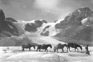
According to Schmitten the trip would take three weeks to complete with several base camps set up along the way so guests could take side trips to places such as the Saskatchewan Glacier. He would do two trips each summer.
With the area growing in popularity there was a push to build a road to connect Jasper and Banff in the early 1920s.
Described as a “wonder trail,” the highway was the brainchild of Arthur Oliver Wheeler, the principal land surveyor in charge of plotting the border between Alberta and British Columbia in the early 1900s.
“Through dense primeval forests, muskeg, burnt and fallen timber and along rough and steeply sloping hillsides, a constant flow of travel will demand a broad, well-ballasted motor road,” Wheeler wrote in a 1920 journal entry. “This wonder trail will be world renowned.”
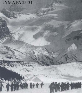
From his photo topographical surveys, construction of a single-track road began in 1931 as part of a depression-era public works program, putting men, machines and horses to work.
“One of the reasons that Parks officials really thought it would be a good idea was that it would help with the argument to get the boundary of Jasper National Park further south to connect with Banff,” said Schmitten.
To get the project going the federal government established relief camps.
“The Icefields Parkway was mostly made by these unemployed men as a relief effort to get them out of the city.”
According to Schmitten, more than 2,000 men were employed during the construction of the road with about 16 men in each camp. The camps were set up about three miles apart with crews starting at each end of the road working towards each other.
To build the road, a surveyor from each camp would work ahead of each of the men to figure out the best way though the valleys.
“The surveyors basically made up the road day-by-day.”
With the unemployment rate hovering around 30 per cent in Western Canada at the time, the government opted to have the men build the road by hand in order to keep them employed for longer.
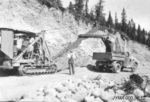
“They needed to make sure the work didn’t proceed too quickly so most of the work was done by pickaxe and shovel,” said Schmitten.
Workers were paid about $5 a month with a stipend for clothing and tobacco. Foremen were paid about $60 a month.
Workers also had to get written permission to leave the camp.
“It was almost like prison these camps, not getting paid much, doing really hard labour and needing permission to leave,” said Schmitten, adding each camp was allotted several horses and a tractor to help with the heavy lifting.
By 1940 the Second World War was well underway and the government brought in heavy machinery to finish the road. It officially opened later that year.
“It took eight years to get from Jasper to the Athabasca and then it took another two years on the Jasper side to the Athabasca Glacier down to what we call the big bend.”
According to Schmitten, the two sides met where Nigel Creek meets with the North Saskatchewan.
Preoccupied with the war, very few Canadians used the road when it first opened, however American tourists took advantage since the United States didn’t officially join the war until Dec. 7, 1941 after Pearl Harbour was attacked.
At its widest point, the gravel/dirt road was 18 feet and cars regularly had to back up or pull over to let others pass. It was also the first road in the world that could take people to the toe of a glacier.
In anticipation of the road’s opening, Fred Brewster built the Icefield Chalet in 1939, which became an attraction unto itself.
“A lot of people came and loved that there was accommodation right at the glacier and for a while during the summers its was a very big summer ski destination,” said Schmitten, adding there was a ski instructor available for lessons.
When the road first opened it would take seven to eight hours to drive the entire distance.
During the war the Canadian Rockies also provided a lot of secrecy for military projects and training, some of which occurred on the Athabasca Glacier.
The Lovat Scouts, a specialized unit with the Scottish Highland regiment of the British Army, used the area to train and practice mountain survival techniques.
“They were a highly trained regiment. They practiced all over the place, in the Tonquin Valley, up at Edith Cavell and the Athabasca Glacier was an important part of their maneuvers,” said Schmitten.
The American 87th Mountain Infantry also spent two months on the Columbia Icefield testing an over-snow vehicle, while British and American soldiers practiced mountain warfare on the glaciers.
By the 1950s, the proliferation of automobiles allowed thousands of people to make the journey and see for themselves the breathtaking scenery. With tourism booming, places like Jimmy Simpson’s ‘Num-ti-jah’ lodge and the Brewster brothers’ Icefield Chalet became popular overnight stops.
“In 1947 it cost two dollars for an annual pass, which included yourself and your own family’s fishing license,” said Schmitten.
The rugged beauty of the area also caught Hollywood’s attention in the 1950s with stars such as Bing Crosby, Jimmy Stewart and Marilyn Monroe shooting movies in the area.
With the influx of visitors the road was paved and realigned in 1962, opening up the Great Divide to thousands of more visitors, with attractions popping up all along the way. In 1969 Brewster began operating their snowmobile tours on the Columbia Icefields.
“It wasn’t until 1960 that the road was actually open in the winter and then it was only open during the day,” said Schmitten.
Today, more than 1.2 million people travel the Icefields Parkway each year, mostly during the summer months.
“I had to laugh because National Geographic had this huge magazine last year and put the Icefields Parkway as one of the world’s ten top most scenic roads and my question is what took them so long?”
This story used excerpts from a previously written story celebrating the 75th anniversary of the Icefields Parkway published by the Fitzhugh in April 2015.
Paul Clarke
[email protected]